Hurricane Betsy 1965

View from the Dupont Plaza of men walking in Hurricane Betsy, Miami, Florida
Background
On September 7, 1965, a hurricane made its way along the southern tip of Florida panhandle. Once it entered the Gulf of Mexico, the storm increased to a Category 5, with calculated wind speeds of over one hundred and fifty-five miles per hour. After moving farther north the hurricane eventually came upon Louisiana.
On September 9th, before making contact with the Mississippi River, the hurricane managed to lose its strength and dropped to a Category 3. Despite this, it did not take away from the water level raising ten feet.
The surge water from the storm managed to make its way up various shipping canals. The levees that were created to divert the excess water failed, leading to one story homes being flooded. Survivors sought shelter atop their own roofs. Unfortunately some individuals did not make it in time and drowned.

View of boat and docks in Garrison Bight destroyed by Hurricane Betsy, Key West, Florida.

Flooding at intersection of First
Street and North Roosevelt Boulevard Key West, Florida
what was lost
Deaths: 76
Damage: Over 160,000 homes were flooded. $1,420,000,000 in damages
Landfall: The Bahamas, Florida, and Louisiana.

Flooding at intersection of U.S. 1 and Flagler Ave. Key West, Florida

View showing home in the Florida Keys damaged by Hurricane Betsy

Coconut tree knocked over on to house on Whitehead Street, Key West, Florida
what was learned
- The levee system was in need of rebuilding, the U.S. Army Corps of Engineers was tasked with this and began construction almost immediately.
- Though unfortunately even after forty years of construction, incentive to complete the project dwindled. So much so that by the time that Hurricane Katrina hit Louisiana the levee system was still not finished.

View of destruction from Hurricane Betsy at the Key West Yacht Club

Trailer overturned by Hurricane Betsy
Signficance
- The Hurricane Protection Program was initiated but the U.S. government as a response to Hurricane Betsy.
- Upon realizing that those affected by the increasing number of hurricanes were not receiving proper insurance, the government decided to create an act that would give insurance to those who live in areas at risk for flooding. This was came to be known as the National Flood Insurance Program (NFIP).
- In 1979, the first real organization to specialize in humanitarian architecture, the Federal Emergency Management Agency (FEMA) was created.
- The NFIP had established what it called a Base Flood Elevation (BFE). It is the calculated elevation that water is set to rise after the initial flood. Building must be built higher than the base flood elevation, to ensure that the rise in water level will not damage the structure.
- The NFIP created hazard zones, and assigned them letter designations such as V and A.
V-Zones = "Coastal High Hazard Areas"
A-Zones = "are not within Coastal High Hazard Areas, although the are below the BFE"
- An example of some of the differences in the regulations between zones are as follows, Buildings built in V zones must be constructed on open foundations such as piles, elevated posts, or piers. This would allow for water to pass beneath them. In A zones, continuous foundations are allowed, because A zones are generally far safer, not having to worry about an excess amount water flooding thew area.

Yachts destroyed by Hurricane Betsy at the Key West Yacht Club
Hurricane Katrina 2005

The devastation of Katrina
background
Arguably one of the most destructive natural disasters in recent American history, Hurricane Katrina was a relentless force of nature. It struck the United States coastline a total of three times. The Florida peninsula was the first area hit by the hurricane. At the time Katrina was measured to be a Category 1 hurricane with eighty mile per hour winds speeds. At the end of it Florida inhabitants found themselves with no electricity, as power lines and trees were strewn about the environment.
After Katrina had plowed through Florida its next target was New Orleans. Citizens were hopeful that the levee system started over forty years ago would be able to stand against the approaching storm. Little did they realize that levee system was still unfinished in certain areas. The oncoming rush of the waves overtopped the levees with little effort.
The last area that Katrina ravaged was along the Mississippi coastline. By the end of the devastation hundreds were dead, tens of thousands of homes were destroyed, and hundreds of thousands were left in unsuitable living conditions. The floodwaters also provided their own dangers as toxic chemical, including waste, were mixed in. It would take nearly a month for the waters to be drained and streets to be cleansed.
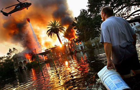
A man watches a house burn on Napoleon Street as helicopters try to extinguish the fires by dropping water from above, on September 4, 2005

Firemen from the Los Angeles Fire Department search through the rubble of buildings along the coastline in East Biloxi, Mississippi on September 7, 2005
what was lost
Deaths: 1,800
Damage: 300,000 single family residences, 40,000 apartments, 300,000 structures, $125-200,000,000 in damages
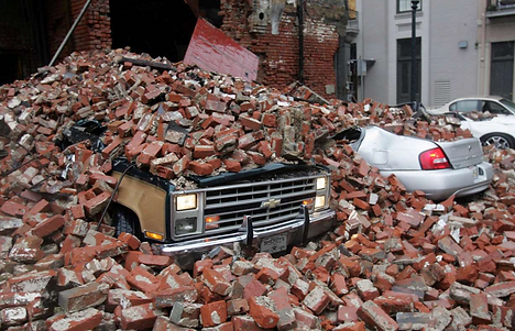
Debris from a fallen building covers several cars in downtown New Orleans after Hurricane Katrina battered the Louisiana coast on August 29, 2005

Floodwaters from Hurricane Katrina fill the streets near downtown New Orleans on August 30, 2005
what was learned
- After discovering that the majority of the damaged houses were in areas that were prone to flooding, FEMA decided to assess the Base Flood Elevations of the area. If New Orleans was going to rebuild they needed to know how high their buildings needed to be raised. Eventually they found that every existing building and future building in New Orleans needed to be raised three feet from the ground.
- One area of controversy is the lax building efforts made by the Corps of Engineers commissioned with reconstructing the levee system after Hurricane Betsy. When it was discovered that the system was still unfinished daft all that time, there was an understandable uproar. Feeling largely responsible and wanting to amend public perception, the Corps snapped back into action repairing the areas that had broken due to Katrina.
- With the flood prevention system failing as many times as it did, an investigation was necessary in order to understand how best to upgrade the system in the future. The American Society of Civil Engineers were the ones who conducted the investigation and eventually they held a conference presenting their ideas on how best to proceed in the rebuilding process.

This is an aerial view of the flooded neighborhood on the east side of New Orleans on September 1, 2005. After Katrina had passed through the area
Signifcance
- Realizing the inadequacy of their hurricane prevention system, Katrina was the disaster that finally necessitated change. The officials in charge realized the grave errors that had been made, and not wanting to be at the mercy of another storm, they listened to the panel held by the ASCE.
- The ASCE Panel had a number of recommendations which are summarized below, as taken from the book "Planning for Disaster: How Natural and Manmade Disasters Shape the Built Environment"(Pages 225-226):
- Public safety should be the highest priority. This seems obvious however it was found that New Orleans levee design was debated amongst the Corps of Engineers, the State of Louisiana, and New Orleans stakeholders. Compromises and shortcuts were made that impacted the safety protocols.
- The public should know the true about the safety the levee system. Assumptions were made about how much damage the levees could actually contain. The public needs to be informed so that the decisions they make are not based on false assumption.
- The redundancy of the flood prevention system should be increased. If the first line of defense were to fail then another backup system should support it. This may mean making multiple levees.
- One person should be in charge of the entire system. This person should be a licensed engineer and not a political appointee.
- The whole system needs to be rethought. Reassess its effectiveness due to age and settling. Make the levees survivable if overtopped and strengthen the system. Upgrade the city's floodwater pumping system.
- The City of New Orleans should make prudent land use decisions. It should consider limiting development in flood-prone areas or, at least, establish minimum first-floor elevations in flood prone areas.

Hurricane Katrina devastated large parts of New Orleans and the Mississippi gulf Coast on August 29, 2005

Homes flooded to the roof by Katrina in Saint Bernard Parish near New Orleans on September 5, 2005